Google Earth Instructional Video Series

yak

Lil-Rokslider
Joined
Feb 9, 2014
Messages
236
Location
Windsor, CO
I just finished a video series on Google Earth (GE) and how I use it to help me effectively scout. I know there is a lot of threads on GE, but hopefully this information is fairly practical. Thought it was worth sharing considering spring fever is right around the corner.

Episode 1: Settings and Overview
Episode 2: Layers/Overlays
Episode 3: Using Google Earth for Effective Scouting

[video=youtube;wYDXqZZE62c]https://www.youtube.com/watch?v=wYDXqZZE62c[/video]
 
OP
yak

yak

Lil-Rokslider
Joined
Feb 9, 2014
Messages
236
Location
Windsor, CO
[video=youtube;iOsp1hxqcjE]https://www.youtube.com/watch?v=iOsp1hxqcjE[/video]
 
OP
yak

yak

Lil-Rokslider
Joined
Feb 9, 2014
Messages
236
Location
Windsor, CO
[video=youtube;UJJPQ1a24GU]https://www.youtube.com/watch?v=UJJPQ1a24GU[/video]
 

Finch

WKR
Joined
Feb 12, 2014
Messages
1,293
Location
VA
Thanks for doing this. Don't have time right now but will check these out soon.
 

JFKinYK

Lil-Rokslider
Joined
Aug 28, 2013
Messages
236
Good info. I learned a few things and already considered myself a Gearth Guru!

You can export a path from Gearth and use third party software to convert the kml to a garmin file and load it as a track into your gps using the software your gps came with. Pretty dang useful when trying to follow specific features on a hike you can see on the imagery. Same with Gearth place marks.
 
OP
yak

yak

Lil-Rokslider
Joined
Feb 9, 2014
Messages
236
Location
Windsor, CO
Good info. I learned a few things and already considered myself a Gearth Guru!

You can export a path from Gearth and use third party software to convert the kml to a garmin file and load it as a track into your gps using the software your gps came with. Pretty dang useful when trying to follow specific features on a hike you can see on the imagery. Same with Gearth place marks.

Great to know, I've never had the need to import back into my GPS, but I could see how useful it could be. Espesially hiking into an unfamiliar area when its dark.
 
Joined
Sep 27, 2013
Messages
78
I'm new at GE, so I will apologize now for the question. I have a hard time finding trailheads, I seen on your video that you put your arrow on an icon and it come up (trailhead). How do I get that option and also do you have a link for the forest service overlay? Thanks for the videos very helpful.
 

Trr15

WKR
Joined
Feb 16, 2014
Messages
1,695
Location
Wyoming
This is great stuff! Thank you for taking the time and for posting these videos. Truly appreciated.
 
OP
yak

yak

Lil-Rokslider
Joined
Feb 9, 2014
Messages
236
Location
Windsor, CO
I'm new at GE, so I will apologize now for the question. I have a hard time finding trailheads, I seen on your video that you put your arrow on an icon and it come up (trailhead). How do I get that option and also do you have a link for the forest service overlay? Thanks for the videos very helpful.

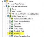
Trailheads can be shown through the 'Layers'.
Trailhead.jpg

There are write-ups of all the content along with the links to the different overlays in the blog post below:
http://www.yakcountry.com/apps/blog/categories/show/1986068-scouting
 
Last edited:
Top