I've used onx in the past but switched to basemaps this year. I'm going to really test it out come September in Colorado but so far basemaps is an easy choice for me way cheaper and easier to use in my opinion.
Hmm, I guess I would have to try that. You can draw and save an area on Gaia as a layer though. It’s called an Area, and you can choose which map layers to include.
Ive been using onx the last many years and its been good. But the image quality is not there. Going on google maps, its night and day difference. Easily can tell whats what vs not so much on my onx map.
Do any of the other map programs have better image quality?
Ive been using onx the last many years and its been good. But the image quality is not there. Going on google maps, its night and day difference. Easily can tell whats what vs not so much on my onx map.
Do any of the other map programs have better image quality?
HuntStand and BaseMap use Google data. Gaia doesn’t. Its stock imagery is decent but you can also manually add Google Earth imagery as a layer. It’s pretty easy and someone on the forum (maybe back in this post) gives instruction on how to do it.
Ive been using onx the last many years and its been good. But the image quality is not there. Going on google maps, its night and day difference. Easily can tell whats what vs not so much on my onx map.
Do any of the other map programs have better image quality?
BaseMap uses Google High-resolution imagery along with a few other satellite options. If you have an iOS device, we also have 3D imagery which is from Apple. $30/year gets you all 50 states
BaseMap uses Google High-resolution imagery along with a few other satellite options. If you have an iOS device, we also have 3D imagery which is from Apple. $30/year gets you all 50 states
I used BaseMap on a Wyoming elk hunt this past October. My only complaint was not being able to keep the topo layer active over a high res image when I tried to use a saved map offline. While online it worked great but I didn’t have service on my hunt so that was a bummer topo didn’t stay as a layer even though it was active when I chose to download it. Luckily I had saved a topo map ( not a layer but a base map rather than a high res image) and it worked to just switch between topo and high res. I’m sure it was user error though cause I’ve seen others talk about it working for them. Other than that small nuisance I really like BaseMap. I also really like the HuntWind feature in BaseMap for whitetail hunting. Helps me plan which stand I’m going to sit based on the wind.
Edit: I also like the fact I don’t have to spend $100 to get all 50 states like mentioned above.
I know these have been discussed but wanted to share my take on them.
I’ve been using the free version of HuntStand for a couple years hunting Missouri private land and MTNF. It got the job done, but they recently locked down some of the free version features so I need to upgrade to a paid app. The three mentioned above all have the basics: Private/public parcel info, GMUs, tracking, offline maps, Topo and satellite maps, etc.
HuntStand has some features that appear to be unique (or at least I haven’t figured them out on the others). You can save “areas” including the parcel boundaries, which is very convenient. I use the wind direction predictor before and during every hunt. The waypoint marker, which I use frequently, is great. It has more maps, including one with hillshading, than OnX but far less than Gaia. It does not have a search feature like the other two, which is inconvenient but not critical. It is the cheapest app at $25 annually for nationwide access.
OnX is a bit easier if searching for areas by owner. It has a few layers that HuntStand doesn’t but less maps. It’s most expensive if you want more than one state ($99) or $29 for one state. I really don’t see much of advantage over HuntStand to justify the cost or to lose all the waypoints I have in HuntStand.
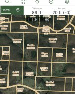
Gaia has the most features, maps, and layers by far. Some of the layers are quite cool and useful (forest service roads, road distance heat map, etc). It’s not even close compared to the other two, and you can stack layers to make it even more versatile. It does pretty much everything both the other apps do except for those feature unique to HuntStand. It doesn’t have as many hunting specific waypoints but I only really use a few types so that’s not a deal breaker. Cost-wise, it is in the middle at $20 or $40 depending on the membership level. Gaia would be a clear winner if not for one thing. .... Its satellite maps have noticeably less resolution than the other two which is a surprising bummer. See pics below. It’s hard to get over that.
Man this is an awesome thread, so informative. Does the Gaia app still list the peoples names like OnX does? I’m contemplating on switching over, even though I only hunt in Michigan I don’t know if I’ll use the option in other states. Although, I may do some hog hunting in Texas this fall.
Man this is an awesome thread, so informative. Does the Gaia app still list the peoples names like OnX does? I’m contemplating on switching over, even though I only hunt in Michigan I don’t know if I’ll use the option in other states. Although, I may do some hog hunting in Texas this fall.