GIS Project Ideas for Student

Clarktar

WKR
Joined
Aug 30, 2013
Messages
4,174
Location
AK
It looks like there is a significant amount of data on beetle kill and wildfires so I suppose I would use that to see if there is any correlation between the two and to what extent.

@Clarktar I really like the idea of doing something the landlocked public lands. Now what would a characteristic be that I could use to prioritize them? Maybe distance from an existing/potential access point (most cost effective?) Size?
Yea it seems like an easy project idea, straight forward and relevant (i.e. lots of articles published about the idea).

The size of land would be a nice criteria to use for prioritization (most bang for buck). You could make it more complicated by trying to see if the state has any classifications or land type as it relates to certain species that overload these landlocked parcels and incorporate that into the prioritization. Also I like the idea of distance to existing road (another cost criteria).

It would be neat to come up with 2-3 ranking criteria to help you prioritize the list of parcels. You could also reach out to some NGO group to see what they might be interested in as far as ranking criteria (TRCP for example).

Sent from my SM-G973U using Tapatalk
 
OP
H

Huntnfish89

Lil-Rokslider
Joined
Mar 6, 2021
Messages
111
Yea it seems like an easy project idea, straight forward and relevant (i.e. lots of articles published about the idea).

The size of land would be a nice criteria to use for prioritization (most bang for buck). You could make it more complicated by trying to see if the state has any classifications or land type as it relates to certain species that overload these landlocked parcels and incorporate that into the prioritization. Also I like the idea of distance to existing road (another cost criteria).

It would be neat to come up with 2-3 ranking criteria to help you prioritize the list of parcels. You could also reach out to some NGO group to see what they might be interested in as far as ranking criteria (TRCP for example).

Sent from my SM-G973U using Tapatalk
I think this might be a top contender. Now the dataset search begins.
 

Clarktar

WKR
Joined
Aug 30, 2013
Messages
4,174
Location
AK
I think this might be a top contender. Now the dataset search begins.
Yea it's scalable as far as complexity. Keep it straight forward simple get a good grade, or go wild make it complicated and coordinate with NGOs who would be interested in leveraging the work

Sent from my SM-G973U using Tapatalk
 

Hoodie

WKR
Joined
Aug 6, 2020
Messages
931
Location
Oregon Cascades
A grad student in Oregon did a similar project on roadkill. It's a good idea.

I'm also currently working on a final project for a GIS class. My instructor gave us topics to choose from, but in my free time I'm doing a weighted composite index analysis to find the best unit to kill a monster black-tail.

I'm obviously putting more effort into my project than the one for the course. Gotta have priorities.
 

gbflyer

WKR
Joined
Feb 20, 2017
Messages
1,591
If you’re in Idaho, an influx of Californian GIS project would be popular


Sent from my iPhone using Tapatalk
 

ODB

WKR
Joined
Mar 24, 2016
Messages
3,782
Location
N.F.D.
If you’re in Idaho, an influx of Californian GIS project would be popular


Sent from my iPhone using Tapatalk

I was thinking snow pack/ reservoirs, watersheds and how an ever-densifying treasure valley is imperiling our long-term water resource.
 

S.Clancy

WKR
Joined
Jan 28, 2015
Messages
2,315
Location
Montana
Conifer encroachment. Find some historic and current aerial photography of the same geographic area and use gis to map the changes. I did a similar study about 25 years ago on a major drainage in western Montana, right as gis was starting to gain steam...lots of thing I would have liked to explore further. I wish the gis technology field would have been further advanced instead of spending 100s of hours delineating 2 sets of photos by hand under a stereoscope.
We've looked at this for work in Lewis and Clark county, the images are pretty staggering from the late 30s-50s until today. Sieben north of town has estimated they are losing something like 80+ acres a year of grazing land to enchroachment.
 
Joined
Dec 31, 2021
Messages
1,654
Location
Montana
I think work done by MBMG ( Bureau of Mines and Geology) show the groundwater can't support the growth in the north Helena Valley.
 

BuzzH

WKR
Joined
May 27, 2017
Messages
2,228
Location
Wyoming
We've looked at this for work in Lewis and Clark county, the images are pretty staggering from the late 30s-50s until today. Sieben north of town has estimated they are losing something like 80+ acres a year of grazing land to enchroachment.
Alpine habitat is taking it on the chin as well...lots of conifer encroachment at higher elevations.

Another thing I noticed was higher stems per acre stand to stand in nearly all tree/ habitat types. Way fewer snags as well...which I believe was due to market demands for house logs and firewood.
 

FatCampzWife

Lil-Rokslider
Joined
Mar 31, 2020
Messages
165
Location
The Plains
I also was browsing through the IDFW datasets and came across some roadkill data. I might try and see if I can use this to determine the areas of most incidents and use that to prioritize locations that animal underpasses might be created....
As a college prof with an understanding of capstone projects, GIS, overachievers, & wanting students to work hard but not kill themselve in an Intro class, this topic seems pretty cool. And do-able. As does the beetle kill project. Could be fun to see if it correlates with trail use, camping areas, roadways, water sources, or wildfire occurrance (or lack of any of those variables).

Good luck, & keep us posted!
 
Joined
Dec 31, 2017
Messages
320
Location
WY
A possible project would be to take the conifer encroachment idea of BuzzH and see how conifer encroachment has affected sage-grouse leks in an area over a few decades.

Conifer encroachment has been identified as issue with sage-grouse leks in the Powder River Basin of Wyoming.

ClearCreek
 

MTtrout

WKR
Joined
Jan 2, 2013
Messages
362
Location
Western Montana
Sounds like you have narrowed down the focus of your project. Data for statewide land ownership is easy to get but being able to identify what is actually land locked public land would present a fun (and maybe difficult) challenge for what is taught in an intro GIS course. I suggest grabbing a statewide road layer and just run with that. You could alway add in the BLM, FS,… and other public access layers if you want. I’d keep it simple and have fun exploring the data layers and your outputs.

Another wildlife focused project idea would be to look at the greater sage grouse range wide layer and relate it to land ownerships across its range. You could brake it down between private and all the state and federal ownerships.

Many cool ideas mentioned but if this is for an intro to GIS project, don’t go over board with layer acquisitions and geoprocessing tools needed to solve your question
 
OP
H

Huntnfish89

Lil-Rokslider
Joined
Mar 6, 2021
Messages
111
I think I have it narrowed down to the roadkill incidents and animal underpass/overpass idea. I am now just trying to think of any other layers that I might add that would help to identify priority other than simply # of incidents. Just thinking about it, I would image that this sort of project would be more applicable in areas outside of city limits or away from established commercial/residential locations were construction would be more difficult. (Maybe a zoning layer here?) I have also considered a terrain/ grade layer (if one is available) that might be helpful in identifying areas where an overpass would work better than an underpass or vise versa. I'm just thinking out loud here.

In any case I am waiting to hear back from my professor to see if this would be an approved project before I fully dive in. Otherwise, I have a number of back up ideas.

I truly appreciate everyone's input so far, it has been extremely helpful and also spurred a couple more ideas for projects of my own. I will be sure to keep you all posted and provide a link to the map when it is close to being done.
 

N.ID7803

WKR
Joined
Nov 25, 2020
Messages
460
Location
N. Idaho
I think I have it narrowed down to the roadkill incidents and animal underpass/overpass idea. I am now just trying to think of any other layers that I might add that would help to identify priority other than simply # of incidents. Just thinking about it, I would image that this sort of project would be more applicable in areas outside of city limits or away from established commercial/residential locations were construction would be more difficult. (Maybe a zoning layer here?) I have also considered a terrain/ grade layer (if one is available) that might be helpful in identifying areas where an overpass would work better than an underpass or vise versa. I'm just thinking out loud here.

In any case I am waiting to hear back from my professor to see if this would be an approved project before I fully dive in. Otherwise, I have a number of back up ideas.

I truly appreciate everyone's input so far, it has been extremely helpful and also spurred a couple more ideas for projects of my own. I will be sure to keep you all posted and provide a link to the map when it is close to being done.
Great idea. GO VANDALS!!!
 

Az wildcat

Lil-Rokslider
Joined
Jan 2, 2016
Messages
101
Location
Arizona
Good evening everyone. In addition to my hunting and fishing "problem" I am also a student at the University of Idaho working on my History degree. I am currently enrolled in an intro to GIS course and trying to come up with some ideas for a final research project that seeks to answer a specific question. I am drawing a blank right now as to ideas, so I figured I would check on here, see if anyone has more experience in this field than me, and hear some ideas of what would be an interesting project for a complete neophyte when to comes to GIS mapping. I am looking for something that would be interesting, but also manageable as far a scope. Basically something that would be relatively approachable for someone at my level.

Some ideas that I have been kicking around are:
Snowpack changes over that past 5 or so decades.
Drought and related changes in plant life (What plants seem to fare better than others etc.)
Maybe something with CWD spread in the West.
Bark beetle infestation and wildfire (compare and analyse?)
I thought doing something on thermal cover would be interesting, but I don't know about that finding datasets that would support this.

Anyways, I just wanted to throw this out there and see if anyone had some thoughts, thanks in advance.

Eddie
Hey Eddie,

I majored in GIS and my favorite project was mapping the spread of Yellowstones wolf population and numbers.

Was a decent visual project and I found it interesting!

The over/under pass one sounds super interesting. It’s normally possible to get accident and traffic data. You could add data around traffic per day or wild life encounters at various times.

One last thing that could be interesting would be adjusting for seasons, especially when you consider the migration of certain animals and highlight specific times of year that are more likely to involve accidents.
 

Rich M

WKR
Joined
Jun 14, 2017
Messages
5,158
Location
Orlando
Do a google

Type in FDEP Map Direct and check out the FL GIS websire i use as part of work. Maybe you’ll get some ideas while looking at it?
 

mhabiger

FNG
Joined
Mar 8, 2021
Messages
70
Location
Kansas City
I think I have it narrowed down to the roadkill incidents and animal underpass/overpass idea. I am now just trying to think of any other layers that I might add that would help to identify priority other than simply # of incidents. Just thinking about it, I would image that this sort of project would be more applicable in areas outside of city limits or away from established commercial/residential locations were construction would be more difficult. (Maybe a zoning layer here?) I have also considered a terrain/ grade layer (if one is available) that might be helpful in identifying areas where an overpass would work better than an underpass or vise versa. I'm just thinking out loud here.

In any case I am waiting to hear back from my professor to see if this would be an approved project before I fully dive in. Otherwise, I have a number of back up ideas.

I truly appreciate everyone's input so far, it has been extremely helpful and also spurred a couple more ideas for projects of my own. I will be sure to keep you all posted and provide a link to the map when it is close to being done.
Zoning is a good idea! I don't believe I've run across any free publicly available datasets at the state or national scale though. Census data has some basic categorizations of their geographies but may not be specific enough. DEM for elevation, land cover for vegetation, there are some national datasets with traffic count estimates and idfg should have range/migration corridor/density data that you could request. Census would also have population density.

Good luck on the project!
 
OP
H

Huntnfish89

Lil-Rokslider
Joined
Mar 6, 2021
Messages
111
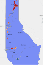
So I just wanted to post an update on the project. I settled on the idea of animal crossings. So far I have the hot spot layers as well as individual incident layers on a map of the Idaho Panhandle (study area), but I am having trouble trying to determine just what method to use in identifying areas where the hypothetical construction of these over/underpasses would be best suited. Any ideas? I was initially thinking about using a layer that identifies "widening potential" in the roadway, but I am wondering if there is better method?
 

Attachments

  • Test Project Study Area.PNG
    Test Project Study Area.PNG
    58.4 KB · Views: 15

wyodan

WKR
Joined
Jan 11, 2013
Messages
729
So I just wanted to post an update on the project. I settled on the idea of animal crossings. So far I have the hot spot layers as well as individual incident layers on a map of the Idaho Panhandle (study area), but I am having trouble trying to determine just what method to use in identifying areas where the hypothetical construction of these over/underpasses would be best suited. Any ideas? I was initially thinking about using a layer that identifies "widening potential" in the roadway, but I am wondering if there is better method?
Look for culverts and roadway cuts in hotspot areas.
 
Top