Silveroddo
WKR
- Joined
- Apr 13, 2019
- Messages
- 487
Hey There,
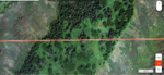
I've got a pretty rookie question about doing some Alaska Escouting and I hope it doesn't come off with a lot of ignorance, I've attached some screen shots and am just trying to make sure I know what I'm looking at and get a better understanding of the terrain features. For scale both red lines are 800 yards. I hope this isn't going to be to vague but I've dropped some letters on this screen shot and am interpreting them as follows
A- Probably pretty thick Brush, poor visibility, tough to get through
B-Open Park, Decent Travel, Decent Visibility (possibility of tall grass?)
C- Trying to determine how this compares to D and how traversable it is
D- Trying to determine how this compares to C
E- Wet/Swamp/Marsh
I'm trying to help my uncle do some scouting on an area he hunted many years ago, they never had access to this level of technology and the imagery of the specific spot they hunted is low quality so its kind of difficult to correlate what he saw v.s. the imagery to use as a baseline for scouting beyond where he hunted. I'll be posting one more pic and that's where my concern and the main body of the question lies.