onX Hunt Tutorial/Q&A

onX Hunt

Lil-Rokslider
Joined
Jun 17, 2015
Messages
235
Location
Montana
It was brought up last week so this week we're going to cover COMPASS MODE.
The map defaults to North up orientation, when you're going to a waypoint or following a previous track that isn't very helpful which is why we have a compass mode which orients the map in whatever direction you are facing.
.....................
Tapping the My Location Button in the bottom-right corner has a number of features such as centering the map on your location, orienting the map in the direction you're facing and displaying a compass on the screen.
118859

Tapping Once
  • Centers the map on your current physical location
  • Your location is indicated by a blue dot
118857

Without moving the map, tap the location icon again which:
  • Rotates the map so the direction you're facing is towards the top of the screen (instead of North-Up)
  • Displays the compass in the upper-right corner
118858

Then to disable compass mode, simply touch the location icon again.

Keep the questions coming as we are appreciating all the feedback and hope this helps you fill your tags this fall.
 

Life_Feeds_On_Life

Lil-Rokslider
Joined
May 16, 2017
Messages
262
Location
AZ
A feature that's not crucial but i would like to see is the ability to orient the footprint of your offline area any direction you want. I'll attach a rough example but basically at this time when you go to download your offline area, the location you want must be within a box that is a vertically oriented rectangle. I would like to be able to rotate that area any direction I please before download. I have had instances where the area I plan to be in is more horizontally oriented than vertical. This ability would allow me to download my entire area in one offline box vs having to download two side by side.

Capture.PNG
 

onX Hunt

Lil-Rokslider
Joined
Jun 17, 2015
Messages
235
Location
Montana
A feature that's not crucial but i would like to see is the ability to orient the footprint of your offline area any direction you want. I'll attach a rough example but basically at this time when you go to download your offline area, the location you want must be within a box that is a vertically oriented rectangle. I would like to be able to rotate that area any direction I please before download. I have had instances where the area I plan to be in is more horizontally oriented than vertical. This ability would allow me to download my entire area in one offline box vs having to download two side by side.

View attachment 118868

I see what you mean! Thanks for the feedback and example.
 
Joined
Aug 16, 2018
Messages
1,149
Location
Alaska
Is there any way to see a legend? Different layers show different tjings such as trails or burns. However theres nothing really telling me what those different markings actually mean.
Thanks.
 

generalist

Lil-Rokslider
Joined
Dec 1, 2018
Messages
159
The website app should have an option to start at a place that isn't your GPS location. It makes sense for the mobile app since you're in the field, but I'd venture to say the vast majority of people using the website are doing so from their home or work computers. Sort of annoying to have to zoom out, scroll into the next state and then search for the area I was researching every time I log in. Should be an easy feature to include.
 

Chris76

FNG
Joined
Jul 26, 2019
Messages
16
Location
Blair county Pa
I just got the app and it’s awesome. I emailed onXhumt and to my surprise they responded very fast and helped me with my problem. Usually sites don’t respond or it takes months. I purchased it after the 7 day free trail and cannot say a bad thing about it. Keep it going guys this is a great app
 

bracer40

Lil-Rokslider
Joined
Oct 26, 2016
Messages
126
Location
Ugh, Seattle
The area I’m escouting in Idaho is snow covered in onx. Is there a way to switch the satellite view so I see summer images?
 

TRexF16

FNG
Joined
Aug 22, 2019
Messages
6
Again - great thread and much appreciated. Here's a question about the original tutorial on Offline Data:

When working in an area where I DO have good cell coverage, is there a way to select "Go Offline", and only use my offline maps that I've saved to the phone (so as to NOT use data [$] and to improve battery life) but still be able to receive phone calls or texts? IOW, I don't want to have to turn on Airplane Mode in order to just use my saved content when using OnX, when I am within cell/data coverage.
If I can do this how do I?
If I can't, can you add it to the customer/user wish list with the developers?

Thanks,
Rex
 

onX Hunt

Lil-Rokslider
Joined
Jun 17, 2015
Messages
235
Location
Montana
Again - great thread and much appreciated. Here's a question about the original tutorial on Offline Data:

When working in an area where I DO have good cell coverage, is there a way to select "Go Offline", and only use my offline maps that I've saved to the phone (so as to NOT use data [$] and to improve battery life) but still be able to receive phone calls or texts? IOW, I don't want to have to turn on Airplane Mode in order to just use my saved content when using OnX, when I am within cell/data coverage.
If I can do this how do I?
If I can't, can you add it to the customer/user wish list with the developers?

Thanks,
Rex

You can do this currently, in the Off-Grid tab there are two buttons "Save New Map" (goes through the process of saving a map for offline use) and "Go Offline" (this is what you will use for that. Tap it once and it will turn red and force the app to only use the maps you have saved for offline use but it does not turn off the service of your phone so you can still text, call, etc. )
119858
 

onX Hunt

Lil-Rokslider
Joined
Jun 17, 2015
Messages
235
Location
Montana
The area I’m escouting in Idaho is snow covered in onx. Is there a way to switch the satellite view so I see summer images?

At this time you cannot change the season that the satellite imagery is at, we are at the mercy of our data providers such as Google Imagery for those so we reflect whatever current imagery they offer. Try a couple of different zoom levels as this can vary as to when the pictures were taken.
 

onX Hunt

Lil-Rokslider
Joined
Jun 17, 2015
Messages
235
Location
Montana
Any way to input a new waypoint as a GPS coord?

Could you please explain further what you would like to do?
You can search coordinates by using the magnifying glass icon in the upper right hand corner. After you enter the coordinates there, tap on the results and it will bring the map to that location. From there, you can add a waypoint. If you'd like to see the exact coordinates of a waypoint, tap on the waypoint, then select the 3 dots in the box above the waypoint, then select View and the coordinates of that waypoint will be in the menu that comes up.
 

TRexF16

FNG
Joined
Aug 22, 2019
Messages
6
You can do this currently, in the Off-Grid tab there are two buttons "Save New Map" (goes through the process of saving a map for offline use) and "Go Offline" (this is what you will use for that. Tap it once and it will turn red and force the app to only use the maps you have saved for offline use but it does not turn off the service of your phone so you can still text, call, etc. )
View attachment 119858
Thanks. In the tutorial on how to "test" your offline maps, it said you have to select airplane mode on the phone to get a valid test, if you are within cell coverage. This is what led to my question. Given what you just wrote, does one need to select airplane mode to test the offline maps? It would seem this is not necessary to "go offline", just tap that on the OnX app. Thanks again.
Rex
 

dubllung4

FNG
Joined
Aug 30, 2018
Messages
48
Location
Michigan
Could you please explain further what you would like to do?
You can search coordinates by using the magnifying glass icon in the upper right hand corner. After you enter the coordinates there, tap on the results and it will bring the map to that location. From there, you can add a waypoint. If you'd like to see the exact coordinates of a waypoint, tap on the waypoint, then select the 3 dots in the box above the waypoint, then select View and the coordinates of that waypoint will be in the menu that comes up.

That's exactly what I was looking for. I could not figure it out for the desktop app but did it just fine from my phone. Thank you
 

onX Hunt

Lil-Rokslider
Joined
Jun 17, 2015
Messages
235
Location
Montana
Thanks. In the tutorial on how to "test" your offline maps, it said you have to select airplane mode on the phone to get a valid test, if you are within cell coverage. This is what led to my question. Given what you just wrote, does one need to select airplane mode to test the offline maps? It would seem this is not necessary to "go offline", just tap that on the OnX app. Thanks again.
Rex
Flipping that "go offline" switch would also work to test those offline maps
!
 

onX Hunt

Lil-Rokslider
Joined
Jun 17, 2015
Messages
235
Location
Montana
One of the biggest concerns we hear from people who are weary of using their phone as their GPS unit in the field is battery life. While the battery life on a standalone GPS unit can last longer, we've compiled a list of steps you can do to ensure your phone battery keeps going on an extended trip. Personally, I've even seen phone battery lasting longer than a GPS unit and with the options for lightweight backcountry chargers out there, it's easy to stay charged up. What do you do to save battery while out in the field or what chargers do you recommend?

onX Hunt Battery Saving Tips

Real world battery test from the onX founder
 

onX Hunt

Lil-Rokslider
Joined
Jun 17, 2015
Messages
235
Location
Montana
We recently updated our sharing feature; on top of being able to share waypoints, you can share areas, lines, and tracks. Below is a breakdown of some of the new features and how to share them. A detailed write up can be found at this link.

Updated Sharing Features

Only the original creator of the Markup will be able to share it. Markups that are Shared with you by another user cannot be Shared or edited.

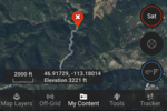
1. Locate the Markup you want to share on your map. If the Markup does not exist yet, create a new Markup at that location.
122350
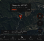
2. Tap the Markup on the map.
3. Tap "Share" in the message bubble above the Markup:
122351
4. A menu of messaging apps will appear on your screen. You use one of these apps to share a link with the other onX Hunt user. onX recommends using text or email, as these are generally the easiest.

If you receive a waypoint from a hunting buddy, here is what it looks like.

1. You will receive a message from the creator of the Markup that begins with: "I want to share..."
This message will most likely arrive via text or email. If you are unable to locate the message, ask the creator of the Markup what method they used to share it.
2. The message will contain a link that looks like this: " ." Tap the link in the message.
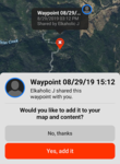
The onX Hunt App will open to the location of the shared Markup and ask if you want to add it to your map and content:
122352
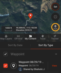
3. Tap the red "Yes, add it" button to add the Markup to your map and My Content Menu.
122353

NOTE: The shared Markup will be listed under the date it was originally created, not the date you received it.

Let us know if you have any other questions about our updated sharing information.
 

Nevvon

FNG
Joined
Mar 17, 2019
Messages
66
To Sync waypoints you marked from onX, you'll need to Export those from the Web Map
This page walks through how to do that - Export from onX

Then you'll upload that file into Garmin Basecamp (free software to view your GPS on a computer) and connect your GPS to the computer and sync it with Basecamp so all those will transfer over.
can you upload from garmin basecamp back to onx? I have been using the chip and just purchased the membership to be able to use my phone instead of carrying additional electronics into the field. It would be very helpful to import all of my garmin handheld data to OnX
 
Top