OnX New Mexico

Joined
Aug 28, 2021
Messages
24
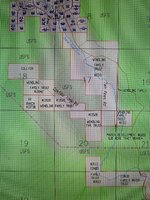
I’m headed on a hunt to New Mexico at the end of the month. I see multiple areas that don’t show any private land ownership but aren’t included in the shaded hunt zone. It just reads “NM Game Management Unit” This is specific to the Gila Region. Although, I’ve only spot checked other areas.

Here’s coordinates to see what I’m talking about:

33.94748, -108.52912


Sent from my iPhone using Tapatalk
 

Bakey

FNG
Joined
May 26, 2023
Messages
14
I think it's wendling family trust
 

Attachments

  • IMG_20230527_212540_01.jpg
    IMG_20230527_212540_01.jpg
    435.4 KB · Views: 17

onX Hunt

Lil-Rokslider
Joined
Jun 17, 2015
Messages
236
Location
Montana
Unfortunately, Catron County has not been able to provide us with a complete parcel coverage map for the county. We have government lands data, but our private parcel map is incomplete at this time. As Catron County builds out their digital parcel data set, we will be sure to include newly added data to the map on our end. For future reference, we do have a map showing our parcel coverage for each county/county equivalent in the country. You can find that coverage map here: https://www.onxmaps.com/hunt/parcel-coverage
 
Top