Caltopo.com has a layer with slope angle shading. Dark, cool colors are bad news. (This is my favorite desktop scouting website, paired with google earth.)
Gaia, very good app also has this feature. Way easier than trying to calculate grade.
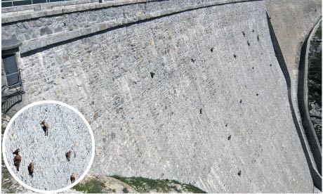
Dang, I need to re-evaluate hiking/climbing...80% is only 10 degree off straight up. I would never approach that kind of slope without ropes and lots of help. Going down at 80 degrees is essentially a controlled fall (? The controlled part if the ground isn’t solid) and would be a disaster for most without ropes and attachment points.
Its definitely doable and not super uncommon during sheep hunts. Its not something you want to do all the time but can be worth it in some instances, especially when retrieving an animal.
Its definitely doable and not super uncommon during sheep hunts. Its not something you want to do all the time but can be worth it in some instances, especially when retrieving an animal.
Its definitely doable and not super uncommon during sheep hunts. Its not something you want to do all the time but can be worth it in some instances, especially when retrieving an animal.
If you are covering 2000 ft in elevation over 500'....um....too steep. The closer the topo lines are the steeper. Many of those closely spaced topo lines indicate cliffs. Avoid closely spaced topo lines and find routes with more open space between topo lines. GE is fun to look at but is just an approximation visually. I've looked at slopes on GE and said......that is doable.....then gotten there in real life and realized I am stoooooped. Way too steep.
Its definitely doable and not super uncommon during sheep hunts. Its not something you want to do all the time but can be worth it in some instances, especially when retrieving an animal.
Its definitely doable and not super uncommon during sheep hunts. Its not something you want to do all the time but can be worth it in some instances, especially when retrieving an animal.
Its definitely doable and not super uncommon during sheep hunts. Its not something you want to do all the time but can be worth it in some instances, especially when retrieving an animal.
Simple answer is look at your map key. It should state the elevation change of each line. Example each contour line represents 40 ft. When you start seeing lines closer and closer it gets steeper and steeper. The key should have the distance scale too measure the distance and count the lines. Example one inch=one mile there are 10 contour lines 40 ft per line, 400 feet gained in that mile.
Its definitely doable and not super uncommon during sheep hunts. Its not something you want to do all the time but can be worth it in some instances, especially when retrieving an animal.