Ballistic Calculators Discrepancies?

OP
A

AM_Hunter

Lil-Rokslider
Joined
Jun 9, 2021
Messages
135
Which one makes your impacts land where they're supposed to?

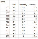
Unfortunately at 500' theyre all about the same, and I don't know where in SoCal (I know im sorry) I can shoot that far at 8000' elevation. Most of the areas that are at elevation are national forests and most national forests in california dont allow target shooting anymore due to fires. I think there may be a range up in the San Bernardino Mountains but I have not been able to check it out to see if I can shoot further than 100 yards. I would prefer to test at elevation if i could. Im going to recheck all my inputs and maybe try a few other apps just for the hell of it. Hornady does seem to be a bit wonky when youre not using hornady ammo so ill check that again
 
OP
A

AM_Hunter

Lil-Rokslider
Joined
Jun 9, 2021
Messages
135
You have an issue somewhere with inputs or something turned on in some of them and not others. All the ballistic apps are extremely close to each other as most are using the same system. If you have more than about .1 mil differences at sane ranges between them- something is off.

Yea im going to check them again, especially the hornady one as that one seems to be the most off. I know a lot of factors play into the calculations but theoretically they should all be similar unless something was input wrong.


1696864741248.png
 
OP
A

AM_Hunter

Lil-Rokslider
Joined
Jun 9, 2021
Messages
135
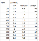
Also coming to realize that pressure does not change much with only elevation, checking multiple weather data sources shows today at ~29.9inHG at anywhere from 500 to 11,000, despite pressure curves saying at 11000 it should be around 22.5inHG. Using this with an elevation of 7200 for the area im hunting i got close numbers for MD and Vortex, hornady still way off though. Dont have a kestrel yet so im gonna run off of OnX's weather data for pressure for now

1696868310934.png
 

Formidilosus

Super Moderator
Joined
Oct 22, 2014
Messages
8,268
Also coming to realize that pressure does not change much with only elevation, checking multiple weather data sources shows today at ~29.9inHG at anywhere from 500 to 11,000, despite pressure curves saying at 11000 it should be around 22.5inHG.

Negative- that is corrected pressure and not what you must use. There are huge differences in actual pressure between 500ft and 11,000ft. Make your life easier and switch to Density Altitude.

It is explained in this thread, I would read the entire thing.

 
OP
A

AM_Hunter

Lil-Rokslider
Joined
Jun 9, 2021
Messages
135
Negative- that is corrected pressure and not what you must use. There are huge differences in actual pressure between 500ft and 11,000ft. Make your life easier and switch to Density Altitude.

It is explained in this thread, I would read the entire thing.


The 29.9inHG is the corrected pressure or the 22.5inHG is the corrected pressure? Damn i thought i was just figuring it out, looks like i gotta do some more reading, thanks
 

Bluefish

WKR
Joined
Jan 5, 2023
Messages
476
Also coming to realize that pressure does not change much with only elevation, checking multiple weather data sources shows today at ~29.9inHG at anywhere from 500 to 11,000, despite pressure curves saying at 11000 it should be around 22.5inHG. Using this with an elevation of 7200 for the area im hunting i got close numbers for MD and Vortex, hornady still way off though. Dont have a kestrel yet so im gonna run off of OnX's weather data for pressure for now

View attachment 611840
The reason is everyone reports corrected pressure as that’s what pilots use for altimeters. Real pressure is about 25inhg at 6200 ft. Density altitude is also used by pilots as it includes temperature. a big deal at a place like Leadville on a hot day. Many small planes simply can’t take off as it’s above their ceiling.
 
OP
A

AM_Hunter

Lil-Rokslider
Joined
Jun 9, 2021
Messages
135
The reason is everyone reports corrected pressure as that’s what pilots use for altimeters. Real pressure is about 25inhg at 6200 ft. Density altitude is also used by pilots as it includes temperature. a big deal at a place like Leadville on a hot day. Many small planes simply can’t take off as it’s above their ceiling.
Gotcha, im currently reading through the link @Formidilosus sent to learn how to calculate DA and will see how that affects the numbers.
 
OP
A

AM_Hunter

Lil-Rokslider
Joined
Jun 9, 2021
Messages
135
Negative- that is corrected pressure and not what you must use. There are huge differences in actual pressure between 500ft and 11,000ft. Make your life easier and switch to Density Altitude.

It is explained in this thread, I would read the entire thing.


Lot of good info in that thread, thanks for sharing it. I really like the DA route, but i am a little confused about one thing, maybe it was mentioned in the thread but I missed it. I was comparing using DA with inputting current real conditions and they were still a little off. Using an altitude of 1430 and a temp of 84F for my current area, I got a DA of about 3400', which told me a mil adjustment of 7.1mil at 700 yards. When I input the weather variables as 1430' elevation, 84F temp, and non corrected pressure from the weather station of 28.31inHG i got a mil adjustment of 6.8. Not a huge difference, just curios what causes the discrepancy. MD Ballistics allows me to input Density Altitude so thats the app I am using for both these inputs.
 

Formidilosus

Super Moderator
Joined
Oct 22, 2014
Messages
8,268
Lot of good info in that thread, thanks for sharing it. I really like the DA route, but i am a little confused about one thing, maybe it was mentioned in the thread but I missed it. I was comparing using DA with inputting current real conditions and they were still a little off. Using an altitude of 1430 and a temp of 84F for my current area, I got a DA of about 3400', which told me a mil adjustment of 7.1mil at 700 yards. When I input the weather variables as 1430' elevation, 84F temp, and non corrected pressure from the weather station of 28.31inHG i got a mil adjustment of 6.8. Not a huge difference, just curios what causes the discrepancy. MD Ballistics allows me to input Density Altitude so thats the app I am using for both these inputs.

Something is still off. Use DA, true the gun up and don’t worry about it. You are jumping through hoops trying to make this work, and it is very simple- solid rifle and scope, a solid 100 yard zero, and trueing at range.


See-

 
OP
A

AM_Hunter

Lil-Rokslider
Joined
Jun 9, 2021
Messages
135
Something is still off. Use DA, true the gun up and don’t worry about it. You are jumping through hoops trying to make this work, and it is very simple- solid rifle and scope, a solid 100 yard zero, and trueing at range.


See-

For sure, do you use a DA calculator or just use the chart?
 

Formidilosus

Super Moderator
Joined
Oct 22, 2014
Messages
8,268
For sure, do you use a DA calculator or just use the chart?

Both- weather meter and the chart. They’re the same. From sea level below 0° and at 100°, to 13,000ft ASL I have never had the chart be off by more than 200 foot DA, and that doesn’t matter at hunting ranges.
 

manitou1

WKR
Joined
Mar 29, 2017
Messages
1,756
Location
Wyoming
Just pick one and then adjust your speed at 600 or below, then your b.c. at 600 fps or above to correct discrepancies.
That would get you close.

To really be honed in you would need to shoot a lot of yardages and continue to tweak... and once you find perfection your barrel will be burned out and you can start over lol. 😁
 
OP
A

AM_Hunter

Lil-Rokslider
Joined
Jun 9, 2021
Messages
135
Just pick one and then adjust your speed at 600 or below, then your b.c. at 600 fps or above to correct discrepancies.
That would get you close.

To really be honed in you would need to shoot a lot of yardages and continue to tweak... and once you find perfection your barrel will be burned out and you can start over lol. 😁
Sorry, little confused. What do you mean by adjust your speed at 600 or below? And when my BC at 600 fps or above?
 

manitou1

WKR
Joined
Mar 29, 2017
Messages
1,756
Location
Wyoming
Sorry, my bad. I meant 600 yds.
Six hundred yards and under, adjust your rifle speed in your ballistic calculator to match drop.

Ex: Your app says to come up 38.5 mils but your rifle requires 39.4 mils to hit the bullseye. Adjust the speed you put in on your app to slow down so that it takes 39.4 mils of adjustment.

Beyond 600 yds you adjust the bullet b.c. to match the drop (come up). This is how you match your actual rifle's performance to the ballistic app you are using.
Same as above but instead of adjusting speed you adjust the b.c. in the app.
 
OP
A

AM_Hunter

Lil-Rokslider
Joined
Jun 9, 2021
Messages
135
Sorry, my bad. I meant 600 yds.
Six hundred yards and under, adjust your rifle speed in your ballistic calculator to match drop.

Ex: Your app says to come up 38.5 mils but your rifle requires 39.4 mils to hit the bullseye. Adjust the speed you put in on your app to slow down so that it takes 39.4 mils of adjustment.

Beyond 600 yds you adjust the bullet b.c. to match the drop (come up). This is how you match your actual rifle's performance to the ballistic app you are using.
Same as above but instead of adjusting speed you adjust the b.c. in the app.
interesting approach. I find that the calculator is pretty accurate at 500' of elevation and pretty consistent among different apps at that elevation. It seems the discrepancies come when I go up in elevation and have to input elevation and pressure changes. Using the density altitude method I was able to get pretty consistent results throughout 3 apps however.

I am just trying to find a method that I can trust when im changing elevations primarily. Like going from sea level to 8000'. Step one is definitely truing my ballistic calculator to my rifle, downside is i cant confirm dope at 8000' as theres no where in SoCal that I know of that I can shoot out to range at that elevation.
 

BULLBLASTER

Lil-Rokslider
Joined
May 29, 2014
Messages
142
Location
Spokane WA
When you enter into the calculator, only enter elevation OR station pressure. Not both.
If you have a way to measure station pressure, use that. If not, use elevation. This assuming you dont want to use DA or your calculator doesnt have that option.
 

Formidilosus

Super Moderator
Joined
Oct 22, 2014
Messages
8,268
interesting approach. I find that the calculator is pretty accurate at 500' of elevation and pretty consistent among different apps at that elevation. It seems the discrepancies come when I go up in elevation and have to input elevation and pressure changes. Using the density altitude method I was able to get pretty consistent results throughout 3 apps however.

I am just trying to find a method that I can trust when im changing elevations primarily. Like going from sea level to 8000'. Step one is definitely truing my ballistic calculator to my rifle, downside is i cant confirm dope at 8000' as theres no where in SoCal that I know of that I can shoot out to range at that elevation.


Do not screw with BC. Find the BC of that bullet and velocity true. It’s takes large differences in BC to cause noticeable shifts in elevation at even 800 yards. The difference in BC variation from rifle to rifle with the same projectile is at most 10 points ( that is from .600 stated BC, to maybe .610 or .590). That’s less than 2 inches at 800 yards for the vast majority of cartridge/bullet combinations.
 
Joined
Sep 10, 2014
Messages
2,349
Location
hawai'i
This assuming you dont want to use DA or your calculator doesnt have that option.
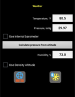
still trying to grasp DA with strelok pro, so if selecting DA i just click use DA and my only inputs are the "temp" and the "elevation"? In the past I just clicked the meteo button and used the nearest weather station inputs.


Screenshot_20231018-164546.png
 
Top