Dope Card for rifle hunting

KNASH

Lil-Rokslider
Joined
Feb 7, 2020
Messages
118
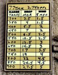
I know I'm supposed to be launching my portable weather station, inputting atmospheric data, altitude, and computing wind direction, then using bluetooth to transfer a shooting solution to my scope, but I'm too old and too slow for all that. My elk hunt plan is to carry a dope card based on low altitude, summer temps MV, assumed altitude and temp, reference the card and dial accordingly. I plan to tape it to the left side of my stock. I need to use geriatric fonts, so can't put a teeny card inside my scope cover.
Question - how do you handle this if not high tech? Open to suggestions.
 

LaHunter

WKR
Joined
Mar 9, 2013
Messages
1,390
Location
N.E. LA
I make a laminated dope card for using at home altitude and a separate one for the ‘ballpark’ elevation I will be hunting when I am in the mountains. I also have an angle cosine card on the back of my high elevation dope card. Things can happen quick when the shot opportunity arises so I don’t want to be fumbling with a ballistic app on my phone
 

Wapiti1

WKR
Joined
Sep 18, 2017
Messages
3,573
Location
Indiana
Yep. Print in size you want and packing tape it to the stock.

I also use a laminated one that is tucked into a buttstock ammo carrier or my bino harness. There is a smaller version taped to the objective bell of my scope too. Usually that one only goes to 600 yards.

Jeremy
 

Big Ern

WKR
Joined
Nov 3, 2019
Messages
342
Location
California
What they said....print tonsize youbwant and tape to stock with clear tape.

make the card ahead of time for average weather/atmospherics/altitude for where youbwill be hunting.

realistically, for hunting not too many elevations. I usually memorize the basics ie what myadjustments are for 200, 300, 400, 500. (to get the distance in between just 1/2 theadjustment between the nex

that has me covered for most everything in case I (1) don’t have time to check my chart; and/or (2) don’t have time to dial and I need to get on the rifle and go straight to hold overs.

anything over 500 yards you usually have plenty of time and need it to make sure you are set uo properly for a stable shot and are confident that you want to take the shot.
 
Joined
Sep 24, 2018
Messages
531
I input the environmental conditions once I get to my hunting location and write it out on a piece of paper in 50 yard increments. Jam it in my pocket and off I go. If I have the time and am setting up where I need a really accurate wind adjustment or the temperature has shifted quite a bit I will input in ballistic app. If I can't do that I won't take the shot.
 

WCB

WKR
Joined
Jun 12, 2019
Messages
3,286
I just print the info out on printer paper. I either actuall laminate it or use packing tape to "laminate it" then tape it to the left side of my stock. I I just print the information with a 10MPH wind. I would never put it on an electronic device or keep it in a pocket. Who wants to be trying to find dope information in a hurry. Way to many guys messing around with crap when they should be concentrating on setting up for the shot.
 
OP
K

KNASH

Lil-Rokslider
Joined
Feb 7, 2020
Messages
118
Thanks for all the responses. I wish I was nimble enough to use a tech solution, but I know my limits. Tape and chart it is.
 

ianpadron

WKR
Joined
Feb 3, 2016
Messages
1,741
Location
Montana
I always tape mine to the butt-stock, but have yet to make it through a whole hunt without the tape peeling off or water getting underneath it.

After a few days of staring at your dope chart you'll have it memorized anyway.
 

Southern Lights

Lil-Rokslider
Joined
Feb 28, 2017
Messages
171
Location
NZ
I write on duct tape and put it on the opposite side of the stock facing away from me upside down.

For instance if you shoot right shoulder, mount your chart on the right side of the butt stock facing away from you when in position and put it upside down. When you want to read it when in position, just tip the rifle in towards you and you can read it the correct way. I find this faster than cocking my head in a weird angle to read the chart closer inside towards me if it were mounted in a conventional location.

I also carry a spare card with multiple elevations/density altitudes in a ziploc bag in my bino harness. This would only be used if doing an exceptionally long shot varmint hunting where the drop is really critical. For any big game hunting range inside 400 yards the altitude/density is not relevant.

Also a tip I learned from PRS, is generate your charts using constant drop values and not based on yards. This way you lookup the range on your card like normal, but the every drop value is an even number. It seems odd at first, but once you try it it makes sense and takes the guess work out of which elevation to use if you are in-between ranges.


Indyal

Lil-Rokslider
Joined
Feb 15, 2020
Messages
146
If I recall correctly, when you order a Leupold custom dial turret, they factor a range of +/- 20 degrees and +/- 2,000 feet. So develop a ballistic chart for your average values, put that into a spread sheet, print it in a font and color you can see in low light, and tape it to the rifle stock. I used some Elmer glue to hold it in place and then covered with clear packing tape.
But I plan to keep my shots under 400 yards on game so the dope sheet is more for target/range use
 

Marbles

WKR
Classified Approved
Joined
May 16, 2020
Messages
3,711
Location
AK
Print on waterproof paper such as Puffin Paper. I have ordered this though waterproofpaper.com. The paper you should get will depend on your printer and toner (inkjet vs laserjet, Etc). A friends dope card that was taped on with clear tape became unreadable on a recent hunt due to moisture.
 
OP
K

KNASH

Lil-Rokslider
Joined
Feb 7, 2020
Messages
118
I write on duct tape and put it on the opposite side of the stock facing away from me upside down.

For instance if you shoot right shoulder, mount your chart on the right side of the butt stock facing away from you when in position and put it upside down. When you want to read it when in position, just tip the rifle in towards you and you can read it the correct way. I find this faster than cocking my head in a weird angle to read the chart closer inside towards me if it were mounted in a conventional location.

I also carry a spare card with multiple elevations/density altitudes in a ziploc bag in my bino harness. This would only be used if doing an exceptionally long shot varmint hunting where the drop is really critical. For any big game hunting range inside 400 yards the altitude/density is not relevant.

Also a tip I learned from PRS, is generate your charts using constant drop values and not based on yards. This way you lookup the range on your card like normal, but the every drop value is an even number. It seems odd at first, but once you try it it makes sense and takes the guess work out of which elevation to use if you are in-between ranges.


OK, I see the point, I ran the JBM calculation, makes sense to pick the closest distance based on MIL adjustments, vs rounding adjustments to even yardages. Thanks!
 
Joined
Oct 30, 2014
Messages
438
Location
Canyon Ferry, MT
Sharpie and bubba tape, on the buttstock.

ClaMQFr.jpg
 
Top