Hold on to your GMU 23/26A Shorts boys

Some board members don't know how to vote on the motion before them. Anyway, a partial closure was always the least worst option we could hope for. Now at their April meeting they need to discuss shared sacrifice among local FQ hunters on cow harvest restrictions according to the WACH WG plan under preservative mgmt.
 
Some board members don't know how to vote on the motion before them. Anyway, a partial closure was always the least worst option we could hope for. Now at their April meeting they need to discuss shared sacrifice among local FQ hunters on cow harvest restrictions according to the WACH WG plan under preservative mgmt.
Sue doesn't know what she is doing either. The guy cant vote on a motion not before him.
 
When the dust settles, it would be appreciated, that pm correspondence goes on as too what the outfitters have decided to do in this regards. Surely this will be a major impact as to how they run thier operations this fall
 
When the dust settles, it would be appreciated, that pm correspondence goes on as too what the outfitters have decided to do in this regards. Surely this will be a major impact as to how they run thier operations this fall
I certainly won't speak for them, but I'd imagine they will still drop people along the rivers on state land right in front of or within caribou. It would then be up to the hunter if they want to pursue caribou off the river or within the designated state land along the river. That's part of the ridiculousness of all this. The airplanes are likely still going to drop hunters in approximately the same spots. I don't envy the transporters and the phone calls they will have over the next week and months. I guess it comes with the territory of operating up there. Be easy on them fellas, they're as frustrated and as against this as you are.

Does anyone know who has legal authority on this? Troopers? Or would it have to be federal law enforcement?

Is this correct? What passed was the modified OSM version. Even with the modified version, we are all getting pushed onto state land?


Sent from my iPhone using Tapatalk
 
The Noatak National Preserve in unit 23 and the Nigu river portion of it in 26a along with all BLM land between the Noatak and Kobuk rivers will be closed for hunting if caribou by NFQ Users in the 22/23 AND 23/24 regulatory years. From August 1 to September 30.


Sent from my iPhone using Tapatalk
 
Yes. And, again I’m not sure the law allows this. Under temporary special actions, they can only last for 60 days (which is where they get away with August —September 30. But to use the WSA to impose this on two years seems like an abuse of the law and a circumvention of the process.


Sent from my iPhone using Tapatalk
 
If I’m even close to right, I hope organizations like the Congressional Sportsman’s Foundation file a lawsuit.


Sent from my iPhone using Tapatalk
 
I wasn't able to call in until the vote. Does anyone have clarification on the Nigu River addition to the modification? I was tracking the Northern border of the Noatak National Preserve was the same as the Southern boundary for 26a. If the Federal land on the preserve is closed between the Noatak and the Kobuk, I thought that'd still leave a lot of room North? Unless the caribou aren't that far North during august/sept.

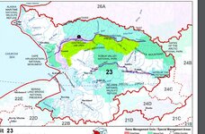
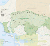
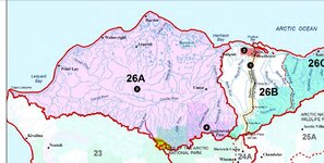
Pardon the crude drawings but I need pictures. Highlighted portions on the maps are where I thought it'd be closed with the addition of that tiny corner of 26a with the Nigu River addition.
 

Attachments

  • 26a.JPG
    26a.JPG
    181.1 KB · Views: 49
  • 23.JPG
    23.JPG
    184.3 KB · Views: 50
  • NPS_kobuk-valley-map.jpg
    NPS_kobuk-valley-map.jpg
    481.5 KB · Views: 48
I believe the closure includes the BLM land between the Noatak and the Kobuk AND ALL of the Noatak National Preserve which gets all the way up to 26a. Then, that added the preserve land within 26a along the Nigu.


Sent from my iPhone using Tapatalk
 
I believe the closure includes the BLM land between the Noatak and the Kobuk AND ALL of the Noatak National Preserve which gets all the way up to 26a. Then, that added the preserve land within 26a along the Nigu.


Sent from my iPhone using Tapatalk
 
Was that part of the new motion? Verbiage from the WSA21-01a is:
"Approve WSA21-01a with modification to close caribou hunting to non-Federally qualified users in Noatak National Preserve and-BLM managed lands between the Noatak and Kobuk Rivers only August 1 to September 30, 2022."

To me that reads as BLM land is closed just between the rivers as well
 
That is, unless they tacked on the "Alternative Geographically Targeted Closure" portion to the modification which does address the area North of the Noatak but doesn't limit the closure to the preserve or give a corridor range.
 
Was that part of the new motion? Verbiage from the WSA21-01a is:
"Approve WSA21-01a with modification to close caribou hunting to non-Federally qualified users in Noatak National Preserve and-BLM managed lands between the Noatak and Kobuk Rivers only August 1 to September 30, 2022."

To me that reads as BLM land is closed just between the rivers as well

I read this as:
Noatak national preserve
And
BLM managed lands between the Noatak and the Kobuk.

Then, when making the motion, Thomas with the BLM added
The Noatak National Preserve land along the Nigu in 26a.

He also added that this would be closed for 2022 and for 2023 making it a two year impact.


Sent from my iPhone using Tapatalk
 
Ahh you are probably right.

I was confused about that because they followed up the course of actions section with the alternative geography wording of "Expanded Closure Corridor on North Side of Noatak River"(p. 79). If it already might be closed to the North via the OSM modification, why address "expanded closure" in a different section?
 
Back
Top