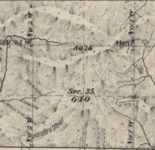
I'm someone who loves maps, and have been making my own custom maps for the areas I elk hunt for the past 3 years. I include a high resolution (3' contours) topo layer, the latest 1' resolution aerial imagery, land ownership, slope/aspect, road layers, place names, and many of the other standard data that is available on OnX, Gaia, GoHunt (but also free if you know where to find it publicly).
My question is, if you had your perfect hunt map, what else would it include?
Over the past few years I've been taking tracks of all the game trails, marking way points for spike camps, marking feeding and rut areas, glassing points, bugling locations, benches, wallows, and coming up with my own names for unique features on the landscape . I've even scoured old BLM maps to find indigenous hunting trails present over a century ago. I'm curious what others would add to their ideal hunt map, and/or what information you want to have written down after a lifetime of getting to know an area.