School me on Kestrel Units

mtnwrunner

Super Moderator
Staff member
Joined
Oct 2, 2012
Messages
3,914
Location
Lowman, Idaho
Except that you can’t in broken terrain.

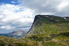
This week we were shooting across, through, up, and down this canyon. The wind at the gun was spot on 90° (Right to left) at 2-4 MPH. Both shooters missed their first shots on a 10” target at just under 600 yards doing what amounts to getting the wind speed and direction from a Kestrel and putting that into the data.
View attachment 565738

The reason they both missed was because they took the direction and speed at the gun as you are wanting, and didn’t notice or observe that they were in a pocket where the wind was blocked by not only the hill to their right 100 yards away, but also that friction from the hill and brush was slowing the wind down at their position. To their right about 100 yards were bushes and trees on the edge of the canyon that showed the wind much higher than 3mph, and not directly at 90°. Additionally, directly to the left was a bowl about 200 yards across that caused the wind to swirl back into itself not only slowing the apparent speed, but quite often showing a left to right wind at the gun, instead of right to left that it actually was.
After their first shots, we went over to the edge and the wind speed at 6-7 foot high was between 8-14mph, with an average of 9 mph.


Using a Kestrel to get the wind degree was useless there. It’s useless in most environments outside of flat prairies and shooting ranges.
Learned a shitload about wind, dope and crappy equipment. A tikka bolt is your friend.......a remington 700.....not so much.
Gonna take up golf.🙂

Randy
 

THLR

Lil-Rokslider
Joined
Mar 6, 2020
Messages
261
Except that you can’t in broken terrain.

This week we were shooting across, through, up, and down this canyon. The wind at the gun was spot on 90° (Right to left) at 2-4 MPH. Both shooters missed their first shots on a 10” target at just under 600 yards doing what amounts to getting the wind speed and direction from a Kestrel and putting that into the data.
View attachment 565738
[...]
Using a Kestrel to get the wind degree was useless there. It’s useless in most environments outside of flat prairies and shooting ranges.

We are drifting off the topic of Kestrels now, but the picture from @Formidilosus was a good reminder that I'm sometimes lost in my own perspective. I'll modify my earlier offhand comment about mountain shooting being easy'ish. For reference, these are my type of mountains and you can see the shooting on YouTube ep 355 (can't link, forum rules)
DSC00484.JPG
Albeit I perhaps have a visually grander or more intimidating scale to the terrain, I have far fewer variables to deal with meaning windcalls across my canyons are a lot easier than across Form's canyons and he is so right when he says "[...]starting point [...]".

  • Both terrains have a relatively "hard friction" meaning wind velocity will increase rapidly with elevation (when compared to softer farmland or water). My attempt to visualize this for beginners is the phrase "Gulliver [the fairy tale giant] will have bleeding knees here, not just skid-marks". The more painful it is visualizing sliding across the ground, the steeper the wind gradient. (if you want to calculate the gradient, the terrain roughness classes is defined in the math required for windmills. Pretty useless for shooting, more important is to simply acknowledge terrain friction and look at relevant places.)
  • We both have the "tunnel effect", where is wind squeezed together/ where will wind velocity increase (my gap reference is the strongest manifestations of this)
  • We both have turbulence and areas with rotor/ false readings. In my terrain they are fairly simple to predict, in his terrain the "interlacing" features of a broken terrain can create many variables that affect each other.
  • My picture is a simple yes/no for question "wind obstacles?" as all obstacles are solid. His pictures adds obstacle porosity to that evaluation. Obstacle porosity is just a fancy way of saying shelter as porosity is more easily classed/numbered into solid 0% pass, dense (trees) 30%, normal trees 50%, open trees 70%. (These definitions comes from Danish Wind Industry Assosciation)
  • If I am sending the bullet ALONG the valley, I simply look far enough out AND make sure I'm not being fooled on direction or strength due shelter and "bounce//ecco". I try to look head high'is. If I have "nothing" but low or even the ancle high vegetation, I take my call from that acknowledge a strong windgradient.
  • If I am sending the bullet ACROSS the valley I try to look top of trees and estimate how high over the ground I'm shooting and add that, very crude intervals 10 meters? 50? 100 or more? The wind engineering theory says appr +30% velocity for each of those steps (not nearly accurate, but simple rules for thumb for field use when alternative is to shoot blind)
The above isn't a solve-all. It's more an "ahem" to help you build experience with variables you might not otherwise discover alone.
You're not going to arrive at a firm number with the above, it will help you avoid the worst pitfalls.
Kestrel has a distinct performance roof as the single datapoint has limited value.
Kestrel removes attention from more important tasks, such as basic marksmanship.
Kestrel steals time from already limited time-windows, possibly rushing the shooter into poor decisions.
I don't believe in Kestrels for wind measurements other than learning to "number" an observation. And I believe choosing a good wind bracket is more important than putting a precise number on wind.
A Kestrel is better than nothing, but not a solution. I definitively wouldn't take money off another budget to splurge for features here.

I'll stop here before I turn it into a nonsense wall of words. These things are so much easier to convey onsite & shooting.
 

Dobermann

WKR
Joined
Sep 17, 2016
Messages
1,678
Location
EnZed
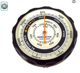
I'm going to play with an analog unit:

1690153637558.png

This ones in metres, but I *think* they do Imperial as well ... for all'y'all still trying to shake your colonial-era math ... ;)
 

SouthPaw

WKR
Joined
Apr 10, 2014
Messages
755
Location
Northern CA
I have a hard data card set at 5,000ft DA, and usually one at 0ft and 10k ft while hunting, a small thermometer, a DA chart, and a mil range cheat sheet on me. Sometimes I’ll do data cards in 2k Ft intervals depending on situation.
They are like an ounce all together and with them I need zero electronics to make shots.
Is there a digital mil ranging cheat-sheet recommended as an example? Everything online seems to be for mil/moa transition or just doesn't seem ideal for printing to put backside of the DA chart.
 

ElPollo

WKR
Joined
Aug 31, 2018
Messages
1,107
I'm going to play with an analog unit:

View attachment 579368

This ones in metres, but I *think* they do Imperial as well ... for all'y'all still trying to shake your colonial-era math ... ;)
I used to use these altimeters for work back in the 90s. They will get you close enough on elevation for your purposes, but you need to set them regularly. Back in the day we did this multiple times per day using benchmarks on USGS quads. But these day a mapping app like On-X, GoHunt, or Gia will probably outperform these.
 

ElPollo

WKR
Joined
Aug 31, 2018
Messages
1,107
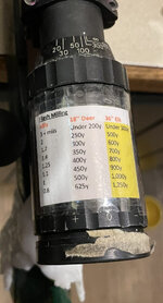
I just saved this off. Very helpful. I used to do something similar but more complicated with a SPF variable with a standard plex reticle. I would use the narrow section on the reticle as a scale and mark my scope adjustment ring with yardages for average chest width. Since I added a rangefinder about 10 years ago, I had given up on that. This is quick and simple for those times when speed is critical or if your rangefinder dies.
 

Formidilosus

Super Moderator
Joined
Oct 22, 2014
Messages
8,266
I just saved this off. Very helpful. I used to do something similar but more complicated with a SPF variable with a standard plex reticle. I would use the narrow section on the reticle as a scale and mark my scope adjustment ring with yardages for average chest width. Since I added a rangefinder about 10 years ago, I had given up on that. This is quick and simple for those times when speed is critical or if your rangefinder dies.

Yep, did the same. And similarly, I used to practice milling a lot more because rangefinders were so unreliable. Then rangefinders got to the point where they were reliable and consistent enough that mil rangeing wasn’t needed anymore. A couple times I used it, but I had memorized simple versions (1 mil back to chest is 500 yards on a deer) that it wasn’t a big deal.
A few years ago I spent a month solid in the mountains with a some buddies in the dead of winter (this is when I really started to understand why AI and Sako put plastic skins on their rifles). It was common to be able to see targets, but not be able to get a laser through blowing snow, fog, or the ice in the air to get a range. On top of the range finder not cutting through it, the batteries were getting killed in the RF’s, the GPS’s and the Kestrels. Multiple batteries per day in the Kestrels even turning it on only to get the environmental data and wind for a specific shot. We ended up having to do a lot of mil ranging, map plotting, etc to get ranges and environmental data.

That lead me back to flash milling for animals. Thinking back there were two times in the previous couple of years that we could not get a range through swirling snow- the most recent was on an elk- two of the RF’s wouldn’t range (Swaro and Meopta), but two did (Nikon Laserforce). The second time we couldn’t get a range at all.

So, I started practicing milling- and particularly flash milling again; switched from using BP, Temp, Alt., to DA; printed a DA card, a milling card, and hard copy drop cards for different DA’s and put them in the bino harness. Putting that little flash milling sheet on the scope/rifle was the last step recently.
After that winter trip, I/we have used milling several times on animals. Once a couple years ago a we stalked up the backside of a small ridge on a herd of elk in a blowing snowstorm. The RF’s wouldn’t get through the snow, and we were periodically getting whiteouts. In between I milled a group of elk and knew they were sub 600 yards. It finally cleared enough for a shot, and the RF got a range- 560y, then it whited out again, cleared, etc. I was able to range a couple of predominant landmarks, one being the closer tree line right at 400 yards. So now we had a bracket of the far ridge at 700, then the smaller fingers were about 80 yards apart, all the way to the tree line at 400y. When the snow cleared the last time I killed one at 560y, the group ran a bit closer to the tree line, my buddy killed one at 408y without ranging first using average gun drops, then whiteout hit again. It would clear a bit and we could see them milling about, whiteout, etc. The last time it cleared they were running towards us and then cutting straight across our front. I flash milled on elk that paused briefly at smaller than 4 mils, not quite 3 mils. Told my buddy elevation 1 mil, and when one pauses, it’s on you. He killed a second one the moment it slowed down. The range afterwards ended up being 280 something yards (288y IIRC).


Using the reticle for ranging is not the reason to have a graduated reticle, as “milling” isn’t precise enough on live animals to use as a primary ranging technique. I also would not say people who’s shooting practice is mainly off a bench, spend time trying to learn and practice it. However, I want all the skill and ability to allow me the greatest chance of killing an animal that is possible. Milling, flash milling in particular; DA, quick math for drops, Wind brackets, rifles that can be shot in all conditions and positions versus specialized setups, cartridges that allow self spotting hits/misses, etc are all a part of that.
 

ShootOkHuntWorse

Lil-Rokslider
Joined
May 23, 2020
Messages
170
I'm going to play with an analog unit:

View attachment 579368

This ones in metres, but I *think* they do Imperial as well ... for all'y'all still trying to shake your colonial-era math ... ;)
I don’t know if most people are familiar with a pilots E6-B but damn it would be handy to have one set up for a specific load that you could order. Has multiple scales built into a rotating disc for finding DA, Distance equations, and fuel burn. Swap out some of those for milling/ranging and wind holds.
 

Formidilosus

Super Moderator
Joined
Oct 22, 2014
Messages
8,266
I don’t know if most people are familiar with a pilots E6-B but damn it would be handy to have one set up for a specific load that you could order. Has multiple scales built into a rotating disc for finding DA, Distance equations, and fuel burn. Swap out some of those for milling/ranging and wind holds.

Accuracy 1st Whiz Wheel. Sort of.
 
Joined
Jul 9, 2023
Messages
10
@Formidilosus - Like some others here I’m also looking at purchasing a Kestrel and currently evaluating available models and features.

Re: the prior discussion about quickly getting DA using the chart shown earlier, my mind is still stuck on some questions about using true altitude (or a close estimate thereof) in place of pressure altitude on the chart.

As I understand, even though the term is pressure altitude and it’s measured in ft MSL, it’s really a back door measure of pressure (not altitude) - namely the altitude equivalent of station pressure given std pressure of 29.92 inHg at sea level and approx. 1-in pressure change per 1,000 ft altitude. It’s not the altitude I’m standing at, but the altitude it “feels” like I’m standing at based on the current station pressure.

So….. If I’m at 6,000 ft true altitude, and NOAA reports a BP of 29.92 (corrected) for my location (station pressure of ~23.92), then I’m at std pressure for my elevation and true altitude does indeed match pressure altitude. In this scenario, if it’s say 85 deg F, I can use the chart to derive a DA of approx 9,200 ft.

Same scenario, except a high pressure system is parked in the area, and NOAA reports a BP of 30.32 inHg corrected. That’s .40 in above standard pressure, equating to roughly a 400 ft change in “felt” altitude. Even though I’m still standing at 6,000 ft, my pressure altitude is now 5,600 ft. Using this value on the chart (still assuming 85 deg F outside air temp), I now derive a DA of somewhere around 8,700 ft.

I guess my question is this - Aren’t we ignoring weather-related effects on barometric pressure by substituting true altitude for pressure altitude on the DA chart? Is my understanding flawed, or is the difference just not consequential for ballistic solutions at hunting distances?

Thanks in advance for helping me wrap my head around this a little better.
 
Last edited:

Formidilosus

Super Moderator
Joined
Oct 22, 2014
Messages
8,266
@Formidilosus - Like some

So….. If I’m at 6,000 ft true altitude, and NOAA reports a BP of 29.92 (corrected) for my location (station pressure of ~23.92), then I’m at std pressure for my elevation and true altitude does indeed match pressure altitude. In this scenario, if it’s say 85 deg F, I can use the chart to derive a DA of approx 9,200 ft.

Same scenario, except a high pressure system is parked in the area, and NOAA reports a BP of 30.32 inHg corrected. That’s .40 in above standard pressure, equating to roughly a 400 ft change in “felt” altitude. Even though I’m still standing at 6,000 ft, my pressure altitude is now 5,600 ft. Using this value on the chart (still assuming 85 deg F outside air temp), I now derive a DA of somewhere around 8,700 ft.

I guess my question is this - Aren’t we ignoring weather-related effects on barometric pressure by substituting true altitude for pressure altitude on the DA chart? Is my understanding flawed, or is the difference just not consequential for ballistic solutions at hunting distances?

Thanks in advance for helping me wrap my head around this a little better.

Yes, but you are leaving out the change in temperature that happens when a weather front moves in. People want to say “but what happens when the weather changes!?”… except that causes a temperature change which almost wholly offsets it.
A great example was today where I live- right at 4,000ft actual altitude and two days ago it was 98°. Actual DA was measured at 7,200ft DA, the chart said 7,300 Ft DA. Today was same exact place, but a storm came in and temperature dropped to 57°. Actual DA 4,600ft, and chart said 4,600 ft DA.

From Florida to New Hampshire, and from Texas to Washington at below sea level to above 12,000 feet, the chart has not been off by more than 200 feet of actual DA in the 4-5 years of been using it. The easier thing to do is to use the chart to figure the DA, then compare it to an actual DA reading from a Kestrel. The people that are worried about “changing weather”, aren’t doing that. They are theorizing.
 

Gila

WKR
Joined
Apr 25, 2020
Messages
1,167
Location
West
The Weatherflow for Precision shooting works well with the GEOballistics app on my iPhone. The Weatherflow is supposed to be supported in Shooter as well. I was using Strelok on my android but that app has been sanctioned so I can’t get it for my iPhone. I like simple display, big numbers and no distraction. The “knobology” of the Kestrel and putzing around with buttons doesn’t work for me. Also I can use the compass in my iPhone to automatically correct GEO when changing targets. GEO is very easy to true up as well. Glad I read this thread because yesterday the battery died on my android phone and I need to get to the range within a few days. I don’t shoot very long range (yet) just need to get dope memorized out to 500 yards for this coming season with my new rifle. This thread has really helped me out…

 
Joined
Mar 6, 2013
Messages
3,079
I’m a little late here. Anyway I found this thread about a week ago searching for info on kestrel units. I’ve been using a weatherflow for years and was looking to upgrade.

Onto the actual question. I was at the range yesterday shooting for some below zero velocity data. Messing around this morning with some of that data. I pulled up my density altitude phone app and it’s calling for negative -1291 density altitude.

Will shooter or other apps actually calculate correctly with that input? Now naturally the answer is to go shoot and see. Unfortunately I’m on the side that has to work today…

I was completely convinced after reading this thread to make the switch to density altitude. I’ll screen shot my DA app numbers and also grab my typical temp, baro pressure (non corrected) and humidity for more messing around.
 
Top