


When I was offered an opportunity to write a review on the BaseMap App Pro Version I was excited. I have some friends who have raved about the app for some time. Rokslide has done reviews in the past (here), and BaseMap has since added and upgraded several features.
This review is not going to cover all aspects of the BaseMap App that have already been hit. We know the ton of features and layers, including detailed private land ownership, multiple maps including water depths, Boone and Crocket layers, or historic fire information. It seems since I started using the app for this review, they have added several more. I’m going to touch on a handful of uses and some of the new features.

3D Hi-Resolution maps
This may be the best feature that BaseMap has and is what sets it apart from other mapping services. It has 3D high-resolution imagery, which is very useful in the field. The ability to have a Google Earth type view of the landscape is something that I have always wanted. It allows you to pick routes better, find glassing spots and shooting lanes better when compared to the flat map views.

Now with that being said, the 3D imagery works best on the iPhone. I use Android. I have seen it in use on the iPhone, and the ability to see the terrain is awesome. With Android, you can still get a little tilt, and it still has Hi-resolution imagery that is still an overall upgrade.

The imagery and tilt are good enough and have enough depth perception that I’ve been able to use the measuring tool to measure distance before dialing on a few long-range 1000+ yard target shots. And was able to be within a couple of yards of my rangefinder reading, but I’m not recommending anyone rely on it in a hunting situation. Overall, even with Android this feature is a definite plus, though not even close to how this feature works with iPhone. I’m sure with how fast BaseMap is improving and upgrading at some point Android will be able to fully use this feature

Outdoor Journal
First off, let me say I was excited about this feature as taking notes while in the field is essential for my scouting business. But keeping a notebook with me and remembering to take notes is not my strong suit. For ADHD people like me, this will be huge. The one thing I always have with me consistently that I haven’t misplaced is my phone (unfortunately, sometimes I wish I’d lose it forever).

The Outdoor Journal allows me to take a note quickly, records my location, time, date, weather data, moon phase, sunset, sunrise automatically. In my eyes, this is a huge asset as all that information can help to figure game patterns out, especially when you look back over a period of time and notice when you see game in certain areas.
Add Photos Too
You can upload pictures to this as well, and share all this information with anybody else who has BaseMap . You can also make it public and share it with everybody, so watch out which buttons you push! Public sharing is a feature that allows you to see what others are sharing and often includes pictures. This is very cool people share a lot of useful info and its another place to see others’ trophies; sometimes they mark the locations to these but you might take that with a grain of salt. I think I will be taking more than I give to this feature.
Smart Weather
Smart weather gives the weather from the nearest weather station, and includes wind direction and speed, moon phase, barometric pressure, sunrise, sunset, and so on… I found it to be accurate and convenient. This can be helpful when entering station data to a shooting app. With that being said, I found I had trouble getting it to load when in mid-to-poor service. Overall, I love these features.

Offline maps
With the BaseMap Pro subscription, you can download hi-resolution imagery offline maps. This has no file size limit and will allow you to download as many maps as your phone will hold. This is a significant improvement over the free version I used in the past, where I was limited to smaller areas and far less detail. Since I have used this, the detail is great, and I can load every area I think I need when going to an area that I may not have service in. In my opinion, this feature alone is worth the subscription.

With my Android I have found that I need very good service to download these maps. From my limited experience with the iPhone and from what I have heard from a couple of well-trusted friends, the iPhone seems to load these far better.

Location Sharing!
This feature is beneficial and offers a lot of possibilities. I believe it will be helpful when transferring information with my scouting business. You can share any of the info entered on a marker. While I haven’t used this feature a lot, I can say that I find it accurate.

My first encounter with this feature involved a friend sending me two points to an elk he’d unfortunately wounded. It was several miles into a trail-less area. One point was the last place he saw the bull, the second was last blood. With just that information, I was able to walk right to the last blood, and sure enough, I saw the blood drops. I ultimately found the bull using those two points, which is a testament to its accuracy in my eyes. I already touched on this above, but you can share the same info you enter in your journal.
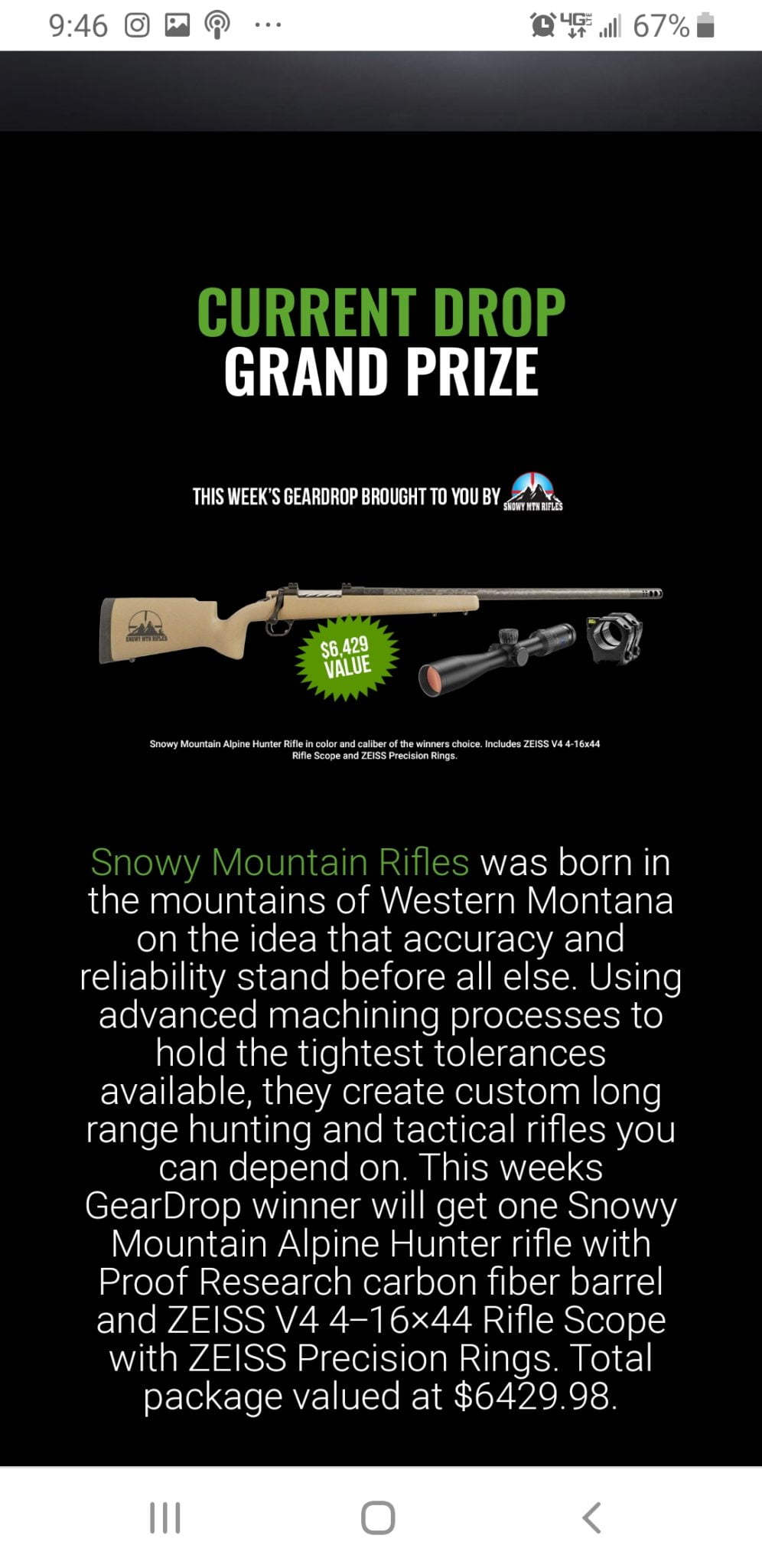
Gear drop
Gear drop is an absolute fun feature. It takes place weekly and not only helps you become more familiar and efficient at using BaseMap. You can win prizes, and these are not lame prizes. These are often gear most of us would love to have with value north of a thousand dollars! One week they had a custom Snowy Mountain Rifle package and Zeiss V4 Scope valued at $6,400 I tried my best that week and was less than 50 yards from the winning location.

Each week BaseMap places a prize at a location within the app. They provide a clue and a boundary, usually a big game unit. You place a marker at your best guess and there are opportunities to add multiple markers. The marker placed closest to the prize wins the prize. Gear drop is a fun feature that keeps us involved throughout the year. People who download the free version are eligible to play this as well.

 BaseMap App Issues
BaseMap was designed around the iPhone, and the issues that I experienced with Android don’t seem to be issues with the iPhone. Actually, some of them seem to be strengths. I have used onX since it came out and have been directly comparing the two side-by-side.
First off, while traveling in areas with medium to low service BaseMap doesn’t load very quickly, whether it’s downloading an offline map or real-time data. It has a hard time loading borders, including land ownership. Often the borders when they do load, have a hard time locking into one spot as they seem to shift a bit for a couple of minutes before fully locking in.
I drive through a lot of country that has below average cell service, and I like to see land ownership, including Block Management areas and any huntable land. When at the same time, the onX map loads quickly in comparison. This can be alleviated by downloading maps before entering an area you plan to go. For people like me who are scouting everywhere they go whether technically scouting or not, it’s less than ideal.
I also find borders like private ownership, trails, roads, huntable areas like BMA’s and other features seem to have a bit less contrast than onX. This is not a big deal and could just be me as I’m so used to looking at onX and the way the borders are marked both by color and contrast–it’s like second nature to decipher. With BaseMaps, the borders while clearly marked don’t seem to have as much contrast and jump out at me as much.
Again, the loading issue doesn’t seem to be the case when using an iPhone and actually from my limited use and what I have heard seems to load faster than onX.
Bottom Line
BaseMap is very affordable and an extremely good value at $29.99 per year for the entire country compared to $99.99 for onX for the same coverage. BaseMaps is on the up and up and they seem to be constantly upgrading and adding features. They already have so many useful features that I don’t have the space to go into detail on every one. Their service team seems to be very helpful and gets back to you quickly when asked questions or presented with issues.
The hi-resolution imagery and 3D capabilities alone are worth the price of admission. For someone with an iPhone, this app is a no-brainer. For my Android, while I find the loading issue to be less than ideal, I also find some of the unique features exclusive to this the app to be very useful and plan to continue to use it, especially with the price being considered. I also plan on updating this article after using this app throughout my summer scouting into the hunting season, so be sure and subscribe to the link below.
You can comment on this article or ask Jim questions here.


